2.5- Time Zones
Instructor's Video Links to an external site.
Today, we live in a world where time is all important. Time governs our lives. We will never know who was the first to try and give measurement to the structure of time but we do know that the Ancient Egyptians used simple sundials as early as 1500 BC.
Prior to the 1880's, clocks were set based on local time, when the sun was at its highest point in the sky (Solar Noon) and adjusted seasonally. There was no need to standardize time so that you would know the precise time at the town 200 hundred miles away or in a country across the sea, because transportation and communication moved slowly. But in the 1880's there were intercontinental railroads crossing the U.S. and the invention of the telegraph (the instant communication of its day) which required us to to standardize time.
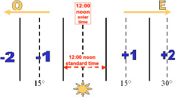 In the same International Conference in 1884, where the Greenwich Meridian, was established as the Prime Meridian, the world adopted standardized time zones. The original design was to create 24 time zones, each spanning 15° of longitude. 12 time zones would be ahead of Greenwich time and 12 time zones would be behind Greenwich time. The 180° meridian in the center of the Pacific Ocean (opposite Greenwich) would serve as the basis for the International Dateline.
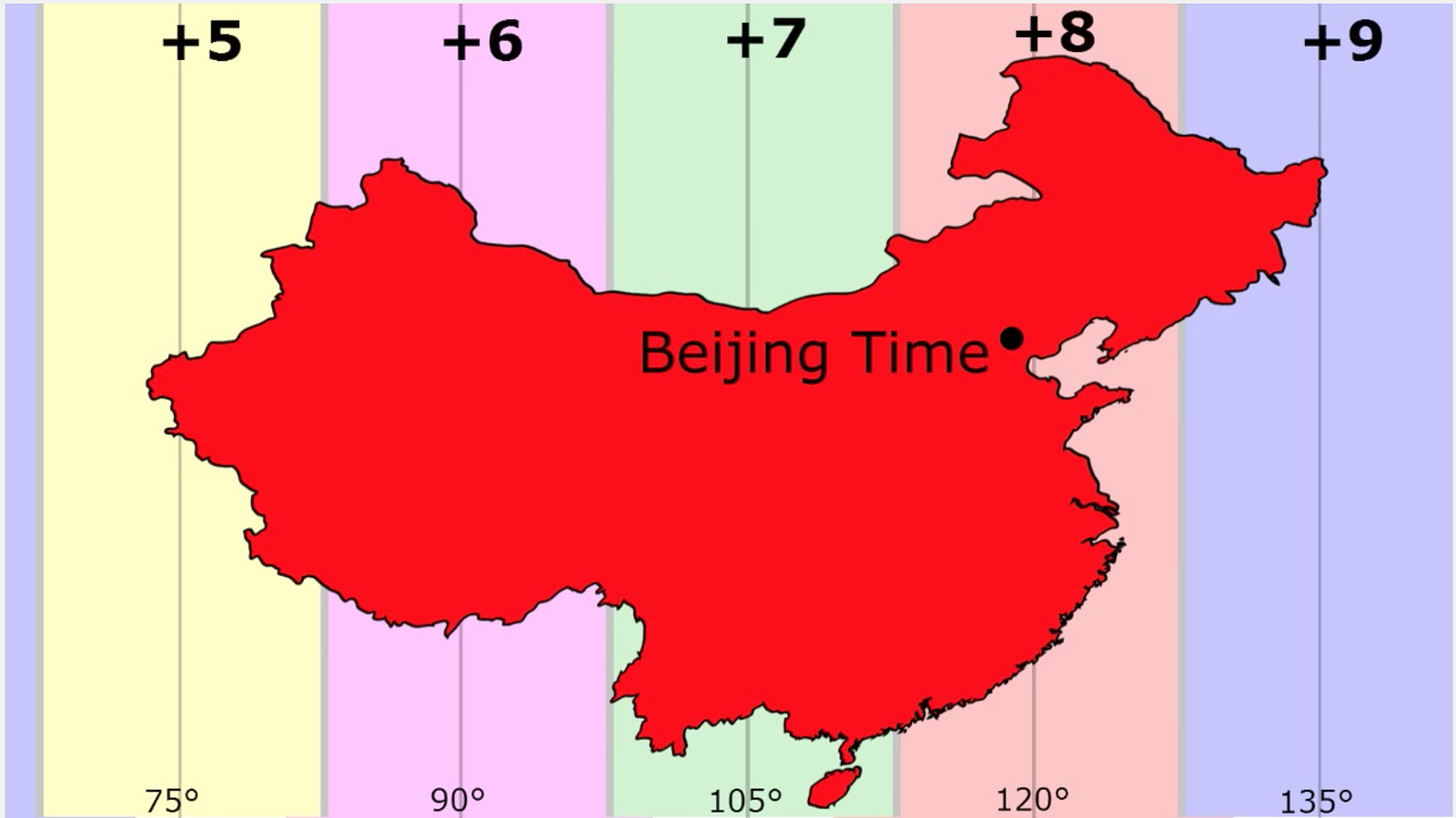 Time zones are based on International Agreement. There are no "time cops" enforcing adherence to time zones. Nations tend to do what works for them while still fitting into the International Community. China, for example, geographically spans 5 time zones. They have chosen to only recognize one time zone. Given the huge geographical dimensions of China's single time zone, solar noon occurs much later than 12:00 in the country's westernmost area (3:10 pm).
The U.S has 6 time zones with some pretty squirrelly boundaries. Some follow Mountain ridges, some follow rivers, the reason for some is a mystery lost to history.

The International Date Line functions as a “line of demarcation” separating two consecutive calendar dates.  When you cross the date line, you become a time traveler of sorts! Cross to the west and it’s one day later; cross back to the east and you’ve “gone back in time" and its a day earlier. Despite its name, the International Date Line has no legal international status and countries are free to choose the dates that they observe. While the date line generally runs north to south from pole to pole, it zigzags around political borders such as eastern Russia and Alaska’s Aleutian Islands.
Another time variable is daylight savings time. By moving the clock ahead one hour in the Spring, it extends daylight hours into the evening. Regions farthest away from the equator and closer to the poles get the most benefit from the DST clock change, because there is a more dramatic change in sunlight throughout the seasons. This works if you are living far enough from the Equator that your length of day is seasonably variable. At the Equator the sun always rises at 6 am (ish) and sets at 6 pm (ish). So daylight savings time does you no good since the length of day is about the same year round. In the US, Hawaii does not participate in daylight savings time for just that reason. Neither does Arizona, ostensibly because the hot temperatures in Arizona don't make DST useful. Again, adherence in the US and around the world is not mandatory, its all voluntary agreement.
Research suggests that with more daylight in the evenings, there are fewer traffic accidents, as there are fewer cars on the road when it's dark outside. More daylight also could mean more outdoor exercise for full-time workers. The nominal reason for daylight saving time has, however, long been to save energy. The time change was first instituted in the United States during World War I, and then re-instituted again during World War II, as a part of the war effort. During the Arab oil embargo in 1979, when Arab members of the Organization of Petroleum Exporting Countries (OPEC) stopped selling petroleum to the United States, Congress enacted a trial period of year-round daylight saving time in an attempt to save energy.
Today we rely on Coordinated Universal Time so that we know the exact time everywhere. Universal Time and the official length of the second are measured by 5 atomic clocks and 200 hundred commercially accurate clocks. Time is so accurate today that we have had to add a leap second each year since 1972 to align our time with the slightly irregular rate of rotation of the Earth.
Watch Tutorial: Using a Time Zone Map Links to an external site.This video will demonstrate how to go "Old School" and find time using a Time Zone Map. I realize this video keeps mentioning an Atlas you don't have... don't let that throw you. You will be using the online Time Zone Map used in the video to complete Assignment 3 - Time and Direction.
|
|---|
Learn More
Learn more about the measurement of time in the 21st century. Links to an external site.