2.4- The Geographic Grid and Navigation
Watch: Instructor's Video - Latitude and Longitude Links to an external site.
Place vs Location
What makes a place? What sets it apart from the space around it, gives it a unique identity? Basically, humans do this through the act of naming or describing how the place is different from its surroundings. Geographers define place as the physical and human characteristics of a location. The physical features might include the local climate, rivers, or valleys. The human characteristics include the culture of the people living in that place and all the ways they interact with it; like building a city or designing a park.
Location is defined as a specific point in space regardless of features or human significance. Locations become places through human actions and thoughts. The physical characteristics used to define place in geography are primarily natural such as lakes, mountains, or local plants and animals. The human characteristics of place involve the people inhabiting the place, their culture, and way of life, as well as how they use and modify the environment around them.
Defining Location

It is critical that Geographers be able to identify a location accurately. If the Earth were flat, we would use a simple grid. But the Earth is an Oblate Spheroid so instead we divide the Earth into imaginary circles that are parallel to the axis of rotation Links to an external site. in one direction and perpendicular to the axis of rotation in the other.
Every location on earth has a "global address "or geographic coordinates. Because the address is expressed in numbers, people can communicate about location no matter what language they speak. Geographic coordinates are given as two numbers called coordinates. The two numbers are a location's latitude and its longitude.
Latitude
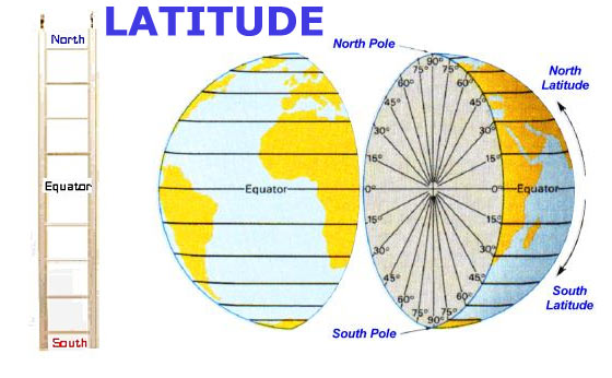
- Lines of latitude are called parallels. They never cross and are different lengths
- Latitude measures the distance of locations north and south of the Equator
- The Equator is an imaginary line drawn around the earth equally distant from both poles, dividing the earth into northern and southern hemispheres and constituting the parallel of latitude 0°. It is the area of maximum bulging due to the Earths rotation
- Every location on Earth has a latitude of between 0° and 90° north and 0° and 90° south.
- There are approximately 69 miles between degrees of latitude
- Latitude is an angular measurement between a point on the surface of the Earth and a point at the very center of the earth. That angle = latitude. Santa Rosa is located at 38°N
- Degrees of latitude can be broken down into smaller units so that we can more accurately describe location. [1° of latitude = 60' (minutes of latitude) Each minute of latitude = about 1.2 miles] [1' of latitude = 60" (seconds of latitude) Each second of latitude = about 102 feet] Santa Rosa is located at 38°26'N
- Today we normally use decimals to express minutes and seconds
- YOU WILL NOT EVER BE ABLE TO DETERMINE MINUTES AND SECONDS FROM A MAP IN AN ATLAS, A MAP ONLINE OR ON A GLOBE - THE SCALE IS TOO SMALL
Seven Significant Parallels of Latitude
Each of these seven parallels of latitude has special significance because of the relationship between the Earth's axis of rotation and the Earth's orbit around the sun. Latitude is based on the physical shape of the Earth.

North Pole and South Poles - 90°N and 90°S. Area of maximum flattening on Earth's Surface
Arctic and Antarctic Circles - 66.5°N and 66.5°S. The Arctic Circle (66.5°N) is the southernmost latitude in the Northern Hemisphere where the sun remains above or below the horizon for 24 hours (on the Solstices; June 21st and December 21st). The Antarctic Circle (66.5°S) is the Northernmost latitude in the Southern Hemisphere where the sun remains above or below the horizon for 24 hours (on the Solstices; June 21st and December 21st).
Tropics of Cancer and Capricorn - 23.5°N and 23.5°S. The Tropic of Cancer (23.5°N) is the northernmost latitude where the Sun ever passes directly overhead at solar noon. This means that if you're located north of the Tropic of Cancer, the Sun is never directly overhead. On noon of June 21st each year, the Sun is directly overhead at the Tropic of Cancer (the summer solstice), marking the beginning of summer in the Northern Hemisphere. The Tropic of Capricorn (23.5°S) is the southernmost latitude where the Sun passes directly overhead. If you are south of the Tropic of Capricorn, the Sun is never directly overhead. On December 21st (the southern hemisphere summer solstice), the Sun is directly overhead at noon on the Tropic of Capricorn, signaling the beginning of summer in the Southern Hemisphere.
The Equator - 0° of latitude. The equator is just under 25,000 miles long. Because the Earth bulges at the center the equator is the longest parallel of latitude. The Sun is directly overhead at the Equator on the Equinoxes (Fall or Autumnal Equinox - September 21; Spring or Vernal Equinox - March 21).
Longitude
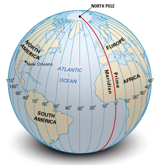
- Lines of Longitude are called Meridians
- Lines of Longitude run from the North to the South Poles where they converge. They are all the same length; half of the circumference of the Earth.
- Longitude measures the distance east and west of a prime meridian or 0° longitude
- There is no physical equivalent of the Equator for Longitude. Meridians are all the same and any would do as the "prime meridian". There is no physical reason to chose one meridian over another. By International Agreement we use the meridian that runs through Greenwich, England as the Prime Meridian (0° degrees of longitude).
- Every location on Earth has a longitude of between 0° and 180°E and 0° and 180°W.
- The distance between degrees of longitude varies from 0 miles at the poles to about 69 miles at the Equator
- Longitude is an angular measurement between a point on the surface of the Earth and a point at the very center of the earth. That angle = longitude . Santa Rosa is located at 122°W
- There are minutes and seconds to describe precise longitude for a location. Today we use decimals. You will not be providing minutes or seconds because the scale of an atlas, globe or and online map will not allow that kind of precision.
Tutorial on using atlas and globes
Watch Tutorial - Latitude and Longitude Using the Atlas and Globes Links to an external site.This tutorial describes using an Atlas that I am not requiring this semester. You will be using online maps instead. Nevertheless, this video is a good introduction to finding and using latitude and longitude on any map - paper or on-line and is mandatory viewing. This semester you will be using online maps to complete Assignment 2- Latitude and Longitude. |
|---|
Watch: Instructor's Video-Navigation at Sea Links to an external site.
Finding Latitude and Longitude at Sea
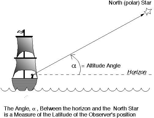

Finding Latitude and finding Longitude at sea are two very different endeavors. Determining latitude can be accomplished relatively easily using celestial navigation. In the Northern Hemisphere, mariners could determine their latitude by measuring the altitude or angle of the North Star (aka Polaris) above the horizon. The angle in degrees equals the latitude of the ship. During the day, sailors would measure the altitude or angle of the sun at solar noon (the sun's highest point) and taking into account changes that occur with the seasons, that angle would equal their latitude. They took those sightings using using a cross staff and later a sextant. They used a compass to maintain their direction and a chip and log to monitor their speed.
There is no straight forward astronomical solution to finding Longitude. Determining longitude was something we did not master until the end of the 18th century. Therefore, all the explorers pre-dating the 19th century were guessing their exact location and many ships were lost because navigators were unable to determine their longitude. The answers to determining longitude were ultimately found both in astronomy and in the measurement of time. Aboard a ship, using time was the only practical method. Using a telescope and making lengthy calculations were impractical at sea so time became the only viable solution. John Harrison invented the Marine Chronometer, a highly accurate clock, in the late 1700's, capable of accurately telling time at sea.

In brief, if you know the the time aboard your ship and the time at port each hour's difference between the two locations equals 15° of longitude which can then be used to find your location. Why? Each 24 hours we rotate through 360° of longitude. Each hour we rotate we rotate through 15° of longitude (360/24 =15). So if its noon on your boat and 2:00 pm at port, 2 x 15 = 30°. You are 30° of longitude from port. In order to fully understand how we use time to determine longitude and to complete your homework, view the tutorial below.
Tutorial on finding latitude and longitude at sea
Watch Tutorial - Finding Latitude and Longitude at Sea Links to an external site.This video describes how to find your latitude at sea and how use time to find your Longitude using time. You will be using this information to complete Assignment 3- Time and Direction.
|
|---|
Learn More
 I know this is a long section with lots to read and watch but if you want to check out something cool, check out the best navigators to ever live.
Polynesian Navigators
Links to an external site.