5.3 - The Landscape of Sub-Saharan Africa
Interior Plateau
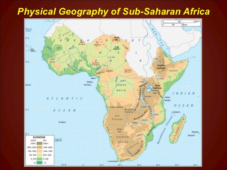
 Africa is big! It is the second largest continent after Eurasia and about 3 times the size of the U.S. But despite its size it is not topographically complex. The center of the continent of Africa is a raised plateau, sloping downward to the north and bordered to the east, south, and west by fairly narrow coastal lowlands. Geologists believe Africa was the center of the ancient supercontinent of Pangea. As land masses broke off from Africa and moved away, Africa only changed position slightly. No continents collided with Africa and as a consequence there are not any long, linear mountain ranges as their are on other continents. There are, however, steep escarpments called the "Great Escarpment" (long, high cliffs) that separate the plateau from the coastal lowlands. This interior plateau was a barrier to transportation and at least initially, to exploration of the continent's interior.
Great Rift Valley
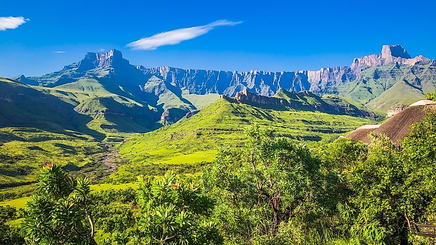
 There is however, tectonic activity occurring in East Africa, where the 2000 mile long "Great Rift Valley", marks the boundary of diverging tectonic plates, tearing the African Plate apart. It extends from the Red Sea in an irregular series of tectonically formed valleys through Ethiopia and into the Great Lakes region where Lake Victoria sits and the headwaters of the White Nile rise. Africa's highest mountains are volcanoes created by this pull apart plate boundary. These include Mount Kilimanjaro (19,324 feet) and Mount Kenya (17,057 feet). At their peaks both have permanent snow and ice.
Sahara Desert
 While clearly, Sub-Saharan Africa does not include the Sahara Desert lets talk about it briefly as it shares the continent. The Sahara Desert exists because of the dominant Sub-Tropical High which persists over north central Africa all year long and because of continentality - the long distance the interior of the Sahara is from any ocean. In some places, temperatures can reach 130°F in the shade at noon. Without much cloud cover and not much vegetation, nighttime temperatures can and do quickly drop below freezing. In some places, uplands get enough rainfall to support grasslands and some trees and a little agriculture. The landscape is quite diverse. Sand dunes, in some cases 600 feet high, cover about 15% of the desert. Mountains, plateaus, gravel covered plains, salt flats and basins cover the remainder. The Sahara contains two perennial (permanent) rivers - the Nile and the Niger. There are at least 20 seasonal lakes and perhaps the world's largest aquifer. 500 species of plants, 70 known mammals, 90 bird species and 100 reptile species call the desert home.
The Sahel
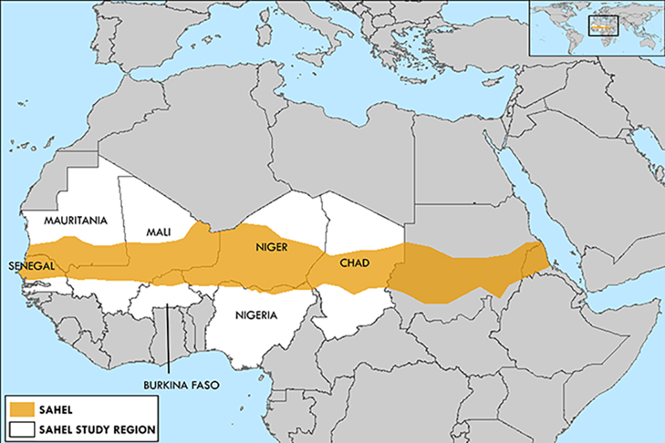 The Sahel is a narrow band of semi-arid land that forms the transition between the Sahara in the north and the Savannas to the south. It is made up of flat plains that run 3300 miles from Mauritania to the Sudan. The Sahel includes the fertile delta of the Niger River, one of the longest in Africa. Eight months of the year, the region is dry. Between June and August rainfall ranges from 6 to 20 inches and the Niger and Senegal Rivers flood creating seasonal grasslands.
Congo Basin
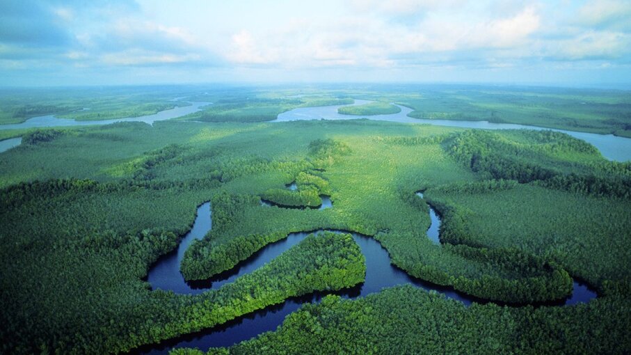 The Congo Basin of the Congo River, sits across the equator in west central Africa. It is the world's second largest river basin. The huge drainage area of the Congo includes the Democratic Republic of the Congo, the Republic of the Congo, the Central African Republic, Western Zambia, northern Angola, and parts of Cameroon and Tanzania. The basin is a fan shaped wedge of tributaries which flow downslope from 900 to 1500 foot highlands. The basin is 1200 miles in dimension north to south. It is home to the second largest rainforest in the world. The forests of the Congo, contain the greatest diversity of mammals, birds, amphibians and fish in Africa. All three species of gorilla reside here.
750 million people live here. There are 150 ethnic groups many of whom still practice a traditional hunter/gatherer life style. The forest is relatively in tact but agriculture, mining, harvesting wood for charcoal, and bush meat hunting are threats.
Ethiopian Plateau
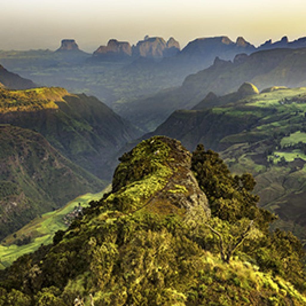 The Ethiopian Plateau covers much of Ethiopia and Eritrea. The plateau includes the east and west highlands which are separated by the African Rift Valley. In the western highlands, the highest peak in Ethiopia is 15,157 foot tall Mount Raj Dejan. In the east, Mount Batu is the highest at 14,127 feet. This area subregion is often called the "horn of Africa" and as the largest continuous highlands in Africa it is sometimes referred to as the
"roof of Africa".
The Great Lakes
The Great Lakes of Africa include some of the largest and most ecologically diverse freshwater systems on the planet. These lakes run down the African Rift Valley. Eight of the fifteen lakes are considered large on a global scale.

Lake Victoria
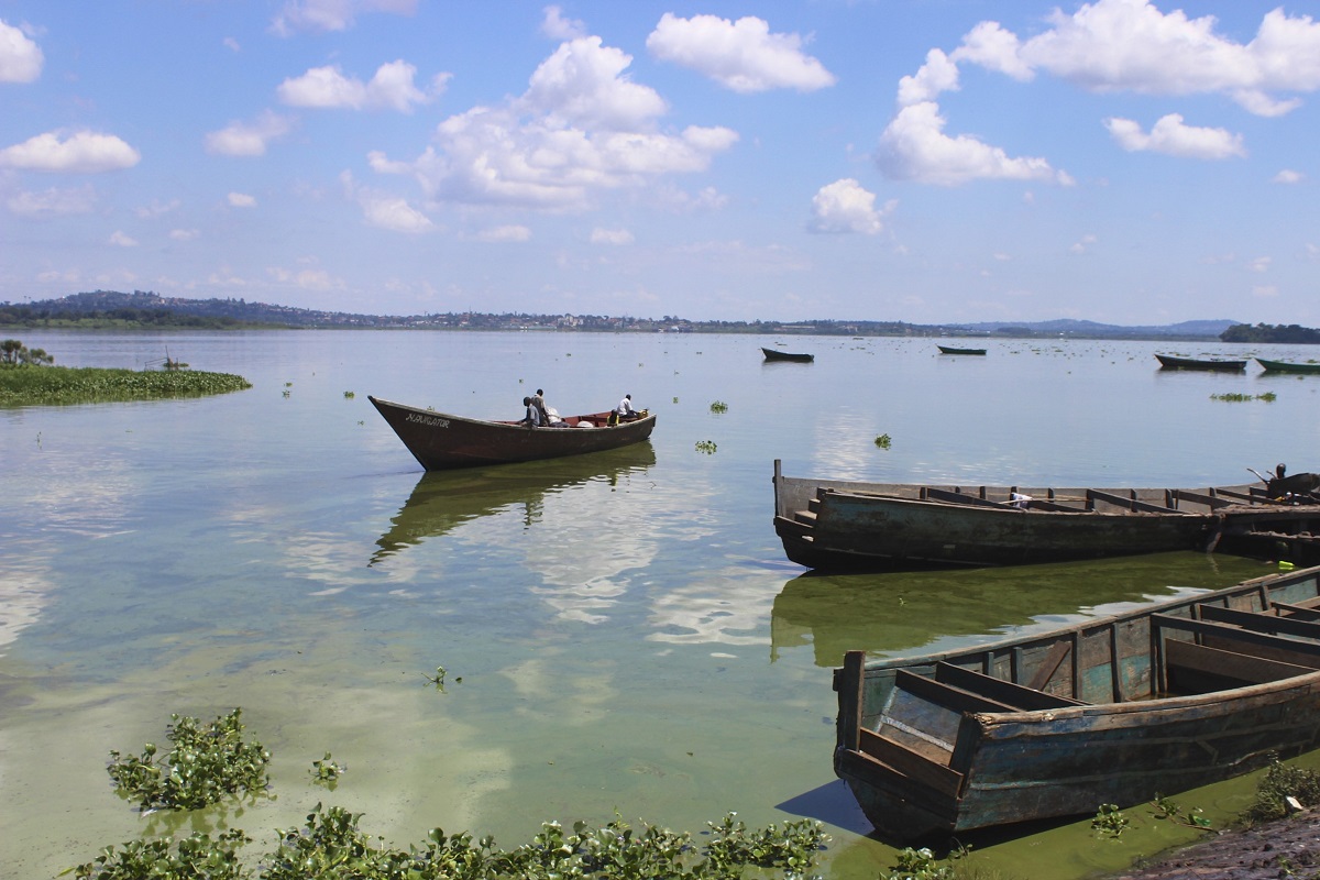 Lake Victoria is the second largest lake in the world. It is the largest tropical lake in the world and is the source of the longest branch of the Nile River, the White Nile. It is relatively shallow at only about 276 feet at its deepest. But the lake is the size of Ireland. Tanzania, Uganda, and Kenya border the lake. It has 1000 islands, many of which are inhabited. 33 million people live around the lake basin. Fishing is a major source of revenue and employment with three million people in the fishing industry. It is a major source of water for domestic use, industry and agriculture. Several large cities totaling five million people get their drinking water from the lake.
Pollution, deforestation, overpopulation and invasive species have completely changed the Lake's ecosystem. Hundreds of species of native cichlid fish species have disappeared. Many are thought to be extinct in the wild. In 1954, the Nile Perch was introduced to the Lake to boost fish catch. Though the Nile Perch is a desirable eating fish, it is also a voracious predator and has destroyed the native fish population. The Nile Perch is an economically valuable catch and is primarily exported. Today 60% of the catch is Nile Perch and 7% is the introduced Tilapia.
This large Lake has other issues including pollution from agricultural runoff and industry. Too much nitrogen and phosphorous has triggered huge blooms of invasive water Hyacinth. Hyacinth depletes the oxygen in the water and makes it difficult to fish commercially.
Lake Tanganyika
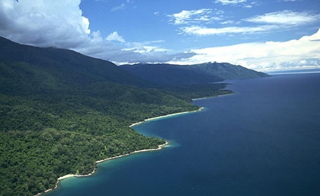 By volume, Lake Tanganyika, is the second largest lake in the world and the second deepest (following Lake Baikal). It is located at the southern end of the Rift Valley and Burundi, the Democratic Republic of Congo, Tanzania, and Zambia border the Lake. Water from Lake Tanganyika feeds the Congo River. The average depth of the Lake is 1870 feet with a maximum depth of 4820 feet. Huge storms sweep the Lake and 20 foot waves are not uncommon.
Tanganyika is one of 20 ancient lakes on Earth estimated to be 9 to 12 million years old. There are 300 endemic species of plants and animals found no where else. Around its shores there is exceptional diversity of plants and animals with 2000 known species. The Lake basin has many forest reserves. One million people live around the Lake. Fishing and transportation are the major human uses of the Lake. Its biggest threat appears to be climate change causing increasing water temperatures.
Lake Malawi
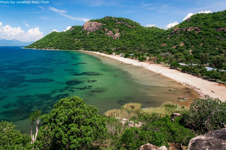 Lake Malawi is the 4th largest freshwater lake in the world by volume. It is the third largest in Africa and the second deepest. It is the southernmost of the Rift Valley Lakes and is bordered by Zambia, Malawi and Mozambique. It is 2300 feet deep at is maximum depth. It is the source of the Shire River which in turn flows in to the Zambezi River. Lake Malawi is what is known as a meromictic lake. In most lakes there is physical mixing between the bottom and top layers of water in the lake at least once per year. In a meromictic lake the water does not mix and three distinct layers exist with different densities due to temperature variations. The Lake is famous for the incredible number and variety of cichlids. It is home to numerous, hippos, Nile crocodiles, monkeys, fish eagles, baboons and antelope. It is used as a fishery, irrigation and drinking water.
Over the last 30 years water levels have dropped as precipitation has declined. Fish stocks have dropped by 90% for the most profitable fisheries.
Kalahari Desert
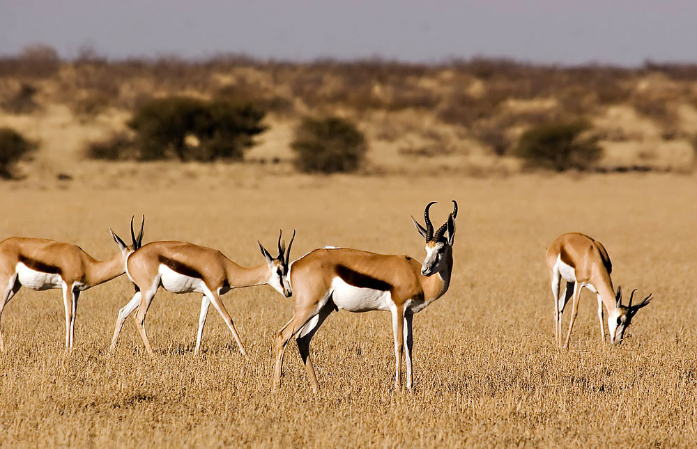 The Kalahari Desert is a large semi-arid sandy savannah in Southern Africa extending for 350,000 square miles, covering much of Botswana, parts of Namibia and regions of South Africa. In the southwest, it merges with the Namib Desert, a coastal desert in Namibia. The desert is at an elevation of about 3000 feet. In the western Kalahari Desert their are sand dunes 20 to 200 feet high. Rainfall varies from 20 inches in the northeast to less than five in the southwest. Springbok, wildebeest, oryx, eland, and kudu are found in the Kalahari. In the north, where there is more water, giraffe, zebra, elephants, buffalo, antelope, lions, cheetah, leopards and wild dog are found.
Cattle are the basis of the economy. Unfortunately, grazing animals are often destructive and can contribute to desertification.
Rivers of Africa
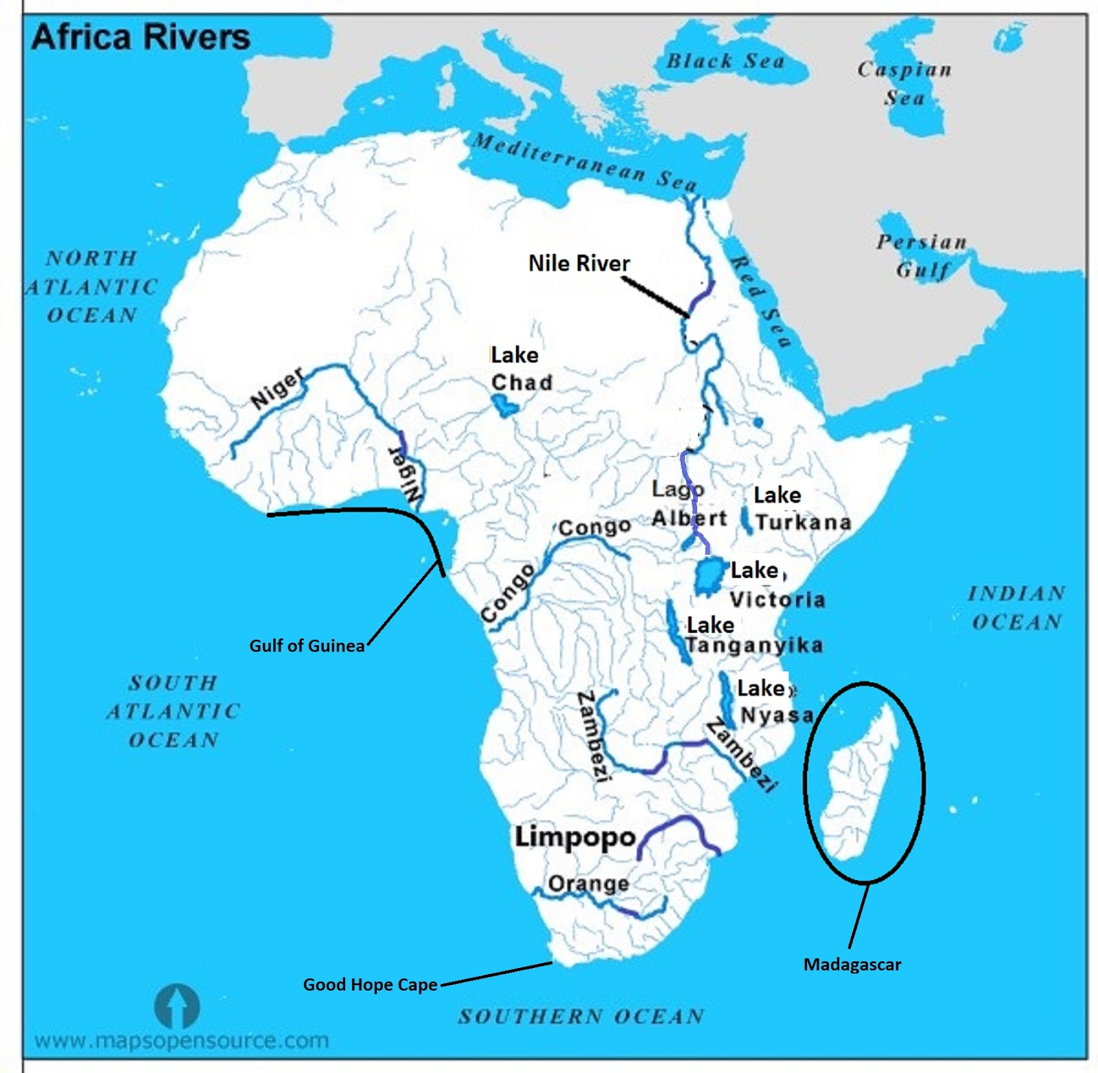
There are six main rivers in Africa:
- The Zambezi River which is fed by Lake Tanganyika and Lake Malawi
- The Nile River which flows north. Its two main branches are the White Nile originating from Lake Victoria and the Blue Nile originating in the Ethiopian Highlands
- The Niger River originating in the Guinea Highlands flowing northeast
- The Congo River
- The Limpopo River in southeast Africa
- Orange River in South Africa, flowing from Lesotho to the Atlantic.