3.2 - Introduction to North America and its Physical Geography
Introduction to North America
Instructor's Lecture:
Links to an external site. Canada
Instructor's Lecture
Links to an external site.: U. S.
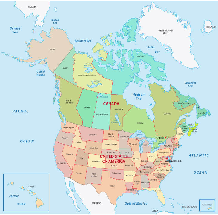 North America is one of the largest, wealthiest, and most politically powerful regions in the World. We define North America as Canada and the United States, two countries that are linked because of their geographic proximity, similar history, and many common cultural, economic, and political features. They share a common history with either a British or French colonial legacy. This a cultural definition of the region. Mexico and much of Central America are physically part of the continent of North America, but culturally they are more connected to South America. They were colonized primarily by the Spanish and Portuguese.
The United States and Canada—the second- and third-largest countries in the world in physical area, respectively—make up more than 13 percent of the world’s total landmass. The North American region is highly urbanized—about 80 percent of the population lives in cities—but vast areas, especially in Canada, are sparsely populated. Although a Native American population remains, most of North America’s diverse population consists of immigrants or descendants of immigrants from other world regions. The United States is the world’s largest economy, and both countries enjoy high standards of living as technologically developed countries.
Here are some basic facts about the two countries:
-
-
-
- Population Canada – 37.59 million, Population of U.S - 328 million
- U.S has 50 states and 14 territories, Canada has 10 provinces and 3 territories
- Canada remains part of the British Commonwealth of nations
- Ottawa is Canada’s Capital City, Washington DC is the US Capital City
- Canada is a Constitutional Monarchy – The King of England is the head of State and the Prime Minister is the head of government
- The US is a Federal Constitutional Republic
- In Canada, French and English have equal status as the official languages
- The US has not adopted an official language
-
-
The Physical Geography of North America: Landforms
Instructor's Lecture Links to an external site.
North America has almost every type of climate and a huge variety of landforms. Huge expanses of mountains and valleys meet vast plains. Long winding rivers flow to some of the World's largest lakes and to three oceans.
-
-
-
- The lowest point in North America: Death Valley, CA. -282 feet
- The highest point: Mt. Denali, AK. 20,310 feet
- The longest river: Missouri-Mississippi River 2,540 miles
- Northernmost point: Cape Columbia, Ellesmere Island (83°N)
- Southernmost point: Ballast Key, Florida (24.5°N)
-
-
Rivers of North America
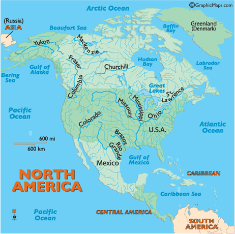 Hundreds of rivers and their tributaries slice across North America. We will focus on a few. The longest river in Canada is the Fraser and it dissects the Northwest Territories. It is 1,200 miles long but combined with its tributaries -the Slave, Peace and Finlay rivers - it is 2,650 miles long and is the second longest river in North America, second only to the Mississippi/Missouri river system at (3,877 miles). The Mississippi is the major river of North America and the United States at 2,339 miles in length. It flows from northwestern Minnesota south to the Gulf of Mexico, just below the city of New Orleans. It is a significant transportation artery and when combined with its major tributaries (the Missouri and Ohio rivers) it becomes the third largest river system in the world at 3,877 miles in length. The Ohio River begins in southern Montana in the Rocky Mountains, first flowing north then generally southeast across the heart of the United States, ending at the Mississippi River, just to the north of St. Louis, Missouri. It is the longest river in the United States at 2,500 miles.
Mountain Ranges
 The geography of the western U.S. and Canada are dominated by mountains, starting with the Pacific Coast Ranges , there are a series of mountain ranges that stretch along the West Coast of North America from Alaska south to Northern and Central Mexico. The Pacific Coast Ranges are part of the North American Cordillera (sometimes known as the Western Cordillera, or in Canada, as the Pacific Cordillera and/or the Canadian Cordillera), which includes the Rocky Mountains, Columbia Mountains, Interior Mountains, the Interior Plateau, Sierra Nevada Mountains, the Great Basin mountain ranges, and other ranges and various plateaus and basins. A cordillera is simply an extensive chain of mountains or mountain ranges. These ranges include: the Saint Elias Mountains, Coast Mountains, Insular Mountains, Olympic Mountains, Cascade Range, Oregon Coast Range, California Coast Ranges, Transverse Ranges, and the Peninsular Ranges.The formation of these mountains includes tectonic and volcanic activity. The tallest Mountain in North America is Mount Denali, in Alaska (20,310 feet)
In the East there are the Appalachian Mountains. These Mountains stretch from the island of Newfoundland in Canada to Central Alabama. These Mountains are much older than the mountains in the West – 480 million years old– and are the oldest mountain range in North America. Once they were as tall as the Alps and Rockies but they have been heavily eroded over time. This is apparent when you note their rounded peaks. These mountains rose during ancient plate collisions. The tallest mountain in the Appalachian Mountains is Mount Mitchel (6, 684 ft) in North Carolina.
Impacts of North American Mountain Ranges
Across the United States and Canada we can see the impacts of these mountain ranges on weather and climate. Most of North Americas mountain ranges trend north/south and the prevailing wind is from the west. The result is the windward or west side of these ranges is wetter and the lee or eastern side is much dryer creating a rain shadow effect and leaving areas to their east very dry. These mountains also served to slow westward expansion as both countries were first settled by colonists in the East. Early colonies found the Appalachian Mountains to be a barrier to expansion. Initially the Rockies and the Sierras also slowed western expansion. Ultimately, colonists expanded from sea to sea. The mountainous regions of North America have been a treasure trove of natural resources for both Canadians and Americans – gold, silver, copper, uranium, timber, oil and natural gas have all been found and exploited in these mountainous regions.
The Great Plains
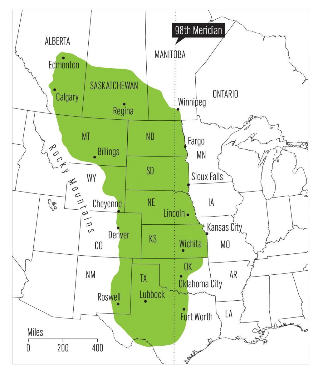
The Great Plains of Canada and the United States form a gentle slope leading from the base of the Rocky Mountains to its eastern boundary running from Winnipeg to Texas. It stretches all the way from Texas to Montana and up into Canada, Manitoba, Saskatchewan and Alberta - totaling over half a million square miles. The Great Plain are 300 to 400 miles wide and 1,800 miles long, The altitude of the plains increases gradually from 600 to 1,200 ft in the east to 4,000–6,000 feet to the west, near the mountains. The plains include many rolling hills, buttes and escarpments.
The Plains have a Continental Climate with cold winters and hot summers and generally limited rainfall due the mountain ranges to the west The Great Plains are drained by the Missouri River and its tributaries and the Saskatchewan River in Canada. Where there is more moisture, they were covered by medium and tall grass prairie. Where there was less, short grass steppe and cactus dominate. Today the original grasslands only survive in small pockets, replaced by agriculture and often, overgrazed ranch land.
The Eastern Seaboard

The Eastern Seaboard of North America is a Coastal Plain that extends along the east and southeast coasts of the United States from Long Island to the Rio Grande. Cape Cod and the islands off south eastern Massachusetts are included in this region. Although narrow in the north, the Atlantic Coastal Plain widens in the south, merging with the Gulf Coastal Plain in Florida. The Atlantic and Gulf coasts were submerged during the last Ice Age, with numerous estuaries, bays , islands, and barrier beaches backed by lagoons. The northeast coast has many natural harbors, such as those of New York Bay and the Chesapeake Bay. A principal feature of the lagoon-lined Gulf Coast is the delta of the Mississippi River.
Atlantic Canada

In eastern coastal Canada the northern continuation of the Appalachians forms, New Brunswick, Prince Edward Island and Nova Scotia. These islands and peninsula’s extending into the Atlantic are known as the Maritimes. They are a mix of rocky coasts, fjords, and forested interiors. The highest tides in the World are found in the Bay of Fundy. Each day they experience a 50 foot tide! Early colonists in the Maritimes were primarily fishermen. Today agriculture, fishing, mining, forestry and natural gas extraction are the primary employment sectors.
The Canadian Shield
 A shield is a large, tectonically inactive mass of some of the oldest rocks on our planet (Precambrian - over 500 million years old). This ancient, crystalline rock that underlies most of a continent. Another name for a shield is craton. A continental shield is an area where these rocks are exposed. The Canadian Shield is the largest mass of exposed Pre-Cambrian rock on Earth. It covers 3 million square miles primarily in Canada and the Great lakes area of the United States. This area was heavily glaciated during the last ice age resulting in a surface that consists of rocky, ice-smoothed hills with an average relief of 100 feet. It includes many irregular basins, which are mostly filled by lakes or swamps. In places the old mountain ranges may be seen as a ridge or belt of hills.
Climate

Because of its great latitudinal extent, Canada has a wide variety of climates. Ocean currents play an important role, with both the warm waters of the Gulf Stream in the Atlantic and the Alaska Current in the Pacific affecting climate. Westerly winds, blowing from the sea to the land, are the prevailing winds in North America and bring coastal British Columbia heavy precipitation and moderate winter and summer temperatures. Inland, the Great Lakes moderate the weather in both southern Ontario and Quebec. In the east the cold Labrador Current meets the Gulf Stream along the coast of Newfoundland and Labrador, causing frequent fog. The northern two-thirds of the country has a climate similar to that of northern Scandinavia, with very cold winters and short, cool summers. The central southern area of the interior plains has a typical continental climate—very cold winters, hot summers, and relatively sparse precipitation. Southern Ontario and Quebec have a climate with hot, humid summers and cold, snowy winters, similar to that of some portions of the American Midwest. Except for the west coast, all of Canada has a winter season with average temperatures below freezing and with continuous snow cover.
A thorough discussion about the climate of the United States is too complex to summarize here but this article Links to an external site. is a good start.
Learn More
Check out the Bay of Fundy's amazing daily tides
Links to an external site.
Check out this video tour of the United States
Links to an external site.
Check out this video of a drive across Canada
Links to an external site.