5.6 - Faulting
Instructor's Video Links to an external site.
Faults and Earthquakes
While rock can bend and fold when pressure and heat are applied over long periods of time, it can also break. When rock is broken and there is movement of the crust on one or both sides of the break, that is faulting. The movement can be vertical or horizontal or a combination of both. Faulting usually takes place along zones of weakness in the crust called fault zones. There is a very strong correlation between seismic activity and plate boundaries.
Movement of the crust along a fault zone is sometimes very slow (creep), but it may also occur as a sudden slip. A sudden release of energy is an earthquake. A single slip may result in displacement of only a few inches or many feet. Successive slips over time can result in displacement of hundreds of miles horizontally and several miles vertically.
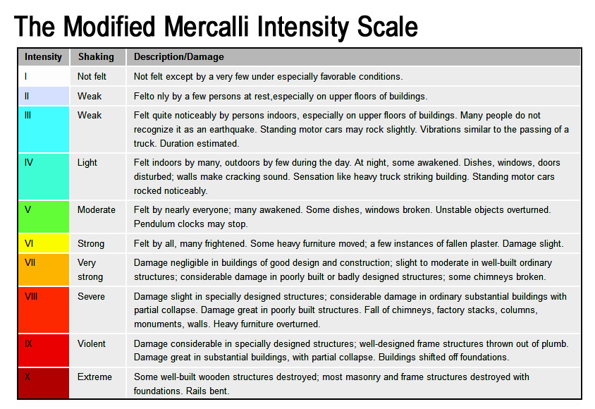
Crustal plates do not move smoothly past one another. Instead, stress causes strain in the rocks along plate boundaries until the sides release and lurch into new positions. The energy released in such a slip is transmitted through the Earth's interior as waves. Seismographs, record those waves. Earthquakes are measured by their intensity and magnitude. Earthquake intensity describes the damage to terrain and structures following an earthquake. The Mercalli Scale classifies earthquakes from I (barely felt) to XI (catastrophic total destruction).
Magnitude is estimated according to a system designed by Charles Richter in 1935. The Richter Scale used a formula based on amplitude of the largest wave recorded on a specific type of seismometer and the distance between the earthquake and the seismometer. That scale was specific to California earthquakes. Unfortunately, the Richter scale does not provide accurate estimates for very large magnitude earthquakes. Today the moment magnitude scale, abbreviated MW, is preferred because it works over a wider range of earthquake sizes and is applicable globally. The moment magnitude scale is based on the total moment release of the earthquake. Moment is a product of the distance a fault moved and the force required to move it. You may notice that many historic earthquakes seem to have a different magnitude than they once did and that is because of the switch from the Richter Scale to the Moment Magnitude Scale. For example, the 1906 earthquake was estimated to be an 8.3 on the Richter Scale but a 7.8 on the Moment Magnitude Scale. Since magnitude scales are logarithmic, an increase of one unit of magnitude on a magnitude scale is equivalent to an increase of 10 times the amplitude recorded by a seismograph and approximately 30 times the energy. See the diagram below and note how much large one magnitude is to the next.

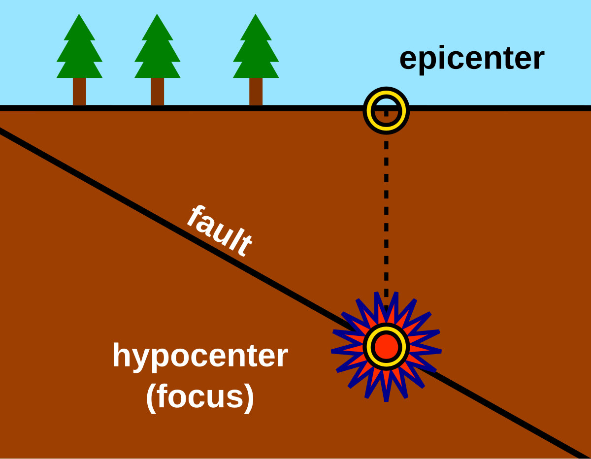
The epicenter in seismology is the point on the Earth's surface directly above the focus, the point where an earthquake originates. Shock waves produced by an earthquake radiate outward from both the focus and epicenter. An aftershock may occur after the main shock, in the same general area as the epicenter. A foreshock is also possible preceding the main shock. Before the 1992 Earthquake in Landers, CA there were a dozen foreshocks along the portion of the fault where the earthquake occurred.
Types of Faults
Although geologists recognize more than two dozen kinds of faults, they can be generalized into four principal types based on the direction and angle of movement.
Normal Faults:
A normal fault results from tension (or pulling apart) in the crust. It produces a fault zone where a block of land on one side of the fault is pushed up (upthrown) relative to the downthrown block on the other side. A fault scarp forms (steep cliff that is the edge of the displaced block).

Normal faults often form in a series. A common feature are horsts and grabens which refer to regions that lie between normal faults and are either higher or lower than the area beyond the faults. A horst represents a block pushed upward relative to the blocks on either side by the faulting, and a graben is the downthrown block forming a valley between upthrown horsts.
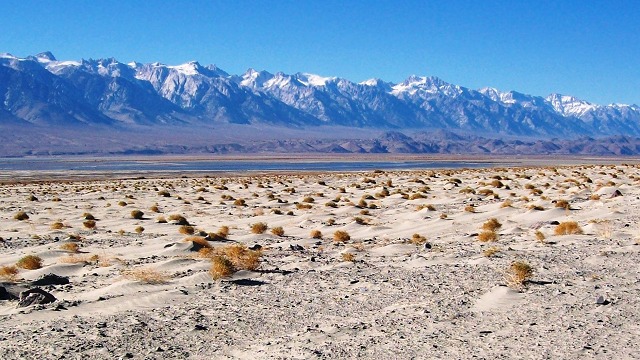
The Rhine River in Europe flows through a series of grabens. Lake Baikal, Earth's deepest lake sits in a graben. The east slope of the Sierra Nevada is a giant fault scarp and is a horst with the Owens and Carson Valley's grabens. The East African Rift Valley is a graben, formed by a new pull apart plate boundary.
Where continental rifting occurs on a vast scale within a continental lithospheric plate, enormous crustal blocks are raised or dropped through faulting. Large scale horst and graben development can occur such as the basin and range country in Nevada and Utah. These "fault block mountains" are associated with ore deposits, hot and cold springs and in some cases, oil or natural gas.

Reverse Fault:
A reverse fault is produced from compression, with the upthrown block rising above the downthrown block. Movement on reverse faults tends to push older rocks over younger ones. One side rides up over the other. Reverse faults produce fault scarps similar to normal faults but the possibility of landslides is greater because and overhanging scarp tends to form. The San Fernando earthquake in 1971 was generated on a reverse fault. Reverse Faults are commonly associated with subduction zones and the world's greatest earthquakes have occurred at these boundaries.


Strike Slip (Transform) Fault
In a strike slip or transform fault the movement is horizontal, with blocks sliding by one another. On an ideal flat plain, no fault scarp would be produced. Instead only a thin line would be traceable across the surface. Streams are sometimes displaced as are hills. The San Andreas Fault is the longest transform fault in the world running some 600 miles from the Gulf of California to the Bay Area.


Thrust Fault
Thrust or overthrust faults are caused by compression just as reverse faults are but in this case, the overthrown block overrides the downthrown block at a lower angle. Just as is the case with reverse faults, these faults are associated with subduction zones.


Great Earthquakes
Chile 1960
Instructor's Video
Links to an external site.
The world's largest earthquakes are associated with subduction zones. The largest earthquake in modern history occurred in 1960, in Valdivia, Chile. It occurred at the subduction zone where the Nazca and South American Plates collide. It was a 9.5 on the moment magnitude scale.
Alaska 1964
Instructor's Video
Links to an external site.
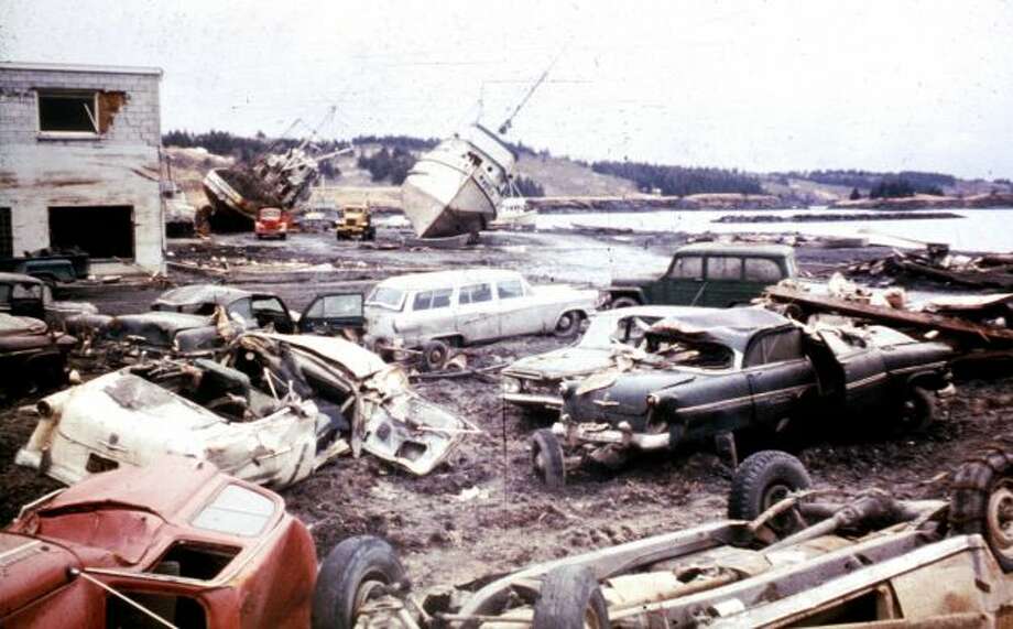
The second largest earthquake in history, and the largest U.S. earthquake occurred in Alaska in 1964, with a magnitude of 9.2. The earthquake lasted five minutes causing extensive ground failures. Ground failures are an effect of seismic activity in which the ground becomes very soft and acts like liquid, causing landslides, spreading, and settling. Massive landslides were triggered by the quake near downtown Anchorage, damaging or destroying about 30 blocks of dwellings and commercial buildings. Water mains and gas, sewer, telephone and electrical systems were all disrupted due to the landslides. This earthquake also occurred at a subduction zone, where the Pacific Plate slides beneath the North American Plate.

Alaska’s continental shelf and North American plate rose over 29 feet during the earthquake. This sudden displacement of the ocean floor, along with earthquake-induced landslides, generated massive local tsunamis that resulted in 70 percent of the fatalities in southern Alaska. The tsunamis created by the earthquake reached land within a few minutes of the ground shaking and engulfed some areas as much as 170 feet above sea level. Scientists measured a wave runup of 220 feet in the Valdez Inlet.
Tsunami waves reached as far away as Hawaii and Japan. Transoceanic tsunamis swept across the Pacific, causing loss of life, extensive flooding, and damaged harbors along the coast of the Pacific Northwest. Coasts and estuaries sustained millions of dollars in damage. Tsunami Links to an external site. waves reached as far away as Hawaii and Japan. Seiches, a harbor wave caused by sloshing of water back and forth in a small body of water, were observed as far away as Louisiana, where a number of fishing boats sunk in a harbor. The tsunami struck Crescent City, Links to an external site.California and killed 11 people.
2004 Sumatra Earthquake and Tsunami
Instructor's Video
Links to an external site.
On December 26, 2004, a 9.1 earthquake occurred at the subduction zone between the India plate and the Burma plate. The giant 2004 Sumatra earthquake ruptured the greatest fault length of any recorded earthquake, spanning a distance of 900 miles, or longer than the state of California. Rather than tearing the land apart all at once, the rupture started beneath the epicenter and progressed northward along the fault at about 1.2 miles/second. The whole rupture lasted about 10 minutes. Imagine the ground shaking so hard that you can not stand for 10 minutes - truly frightening.
When the crustal plates slipped during the earthquake, some islands in the subduction zone grew as they were lifted above the water line, while others tipped over and partially submerged as they subsided. A small island doubled in size during the quake. Other islands and many homes were suddenly submerged as the land subsided during the quake.
As the rupture along the fault occurred, it caused the ocean floor to spring back to the west by as much as 20 feet, as well as uplift another 6 feet. The displacement of the ocean floor shoved the water above it upwards. This giant push of water generated a series of tsunami waves, the first of which hit Sumatra 25 minutes after the start of the quake. The waves had grown to 100 feet high in some places. More tsunami waves struck Thailand two hours later, and other countries around the Indian Ocean were hit a few hours later. Countries hardest hit by the 2004 tsunami included Sri Lanka, India, Thailand, Somalia, Maldives, Malaysia, Myanmar, Tanzania, Bangladesh and Kenya. In all, nearly 230,000 people were killed, making it one of the deadliest disasters in modern history. This giant quake of 2004 was followed just four months later by a magnitude 8.7 quake on March 28, 2005.
2011 Tohoku Earthquake and Tsunami
Instructor's Video
Links to an external site.
A magnitude 9.1 earthquake struck in the Pacific Ocean off the northeast coast of the Tōhoku region of Japan’s Honshu island on March 11, 2011, the fourth largest earthquake in history and the largest ever recorded in Japan. This earthquake occurred on a subduction zone between the Pacific and Eurasian Plates. The fault moved as much as 164–197 feet, and slipped over an area approximately 250 miles long. The March 11th earthquake was preceded by a series of large foreshocks over the previous 2 days, beginning on March 9 with a M 7.4 event approximately 25 miles from the epicenter of the March 11th earthquake, and continuing with another three earthquakes greater than M 6 on the same day.
The sudden horizontal and vertical thrusting of the Pacific Plate, which has been slowly advancing under the Eurasian Plate near Japan, displaced the water above and pushed up a series of highly destructive tsunami waves. Less than an hour after the earthquake, the first of these tsunami waves hit Japan's coastline. The tsunami waves reached run-up heights (run-up: how far the wave surges inland above sea level) of up to 128 feet at Miyako city and traveled inland as far as 6 miles in Sendai. The tsunami flooded an area of approximately 217 square miles in Japan. The waves overtopped and destroyed protective tsunami seawalls at several locations. The massive surge destroyed three-story buildings where people had gathered for safety. Near Oarai, the tsunami generated a huge whirlpool Links to an external site. offshore, captured on video.The number of confirmed deaths is 15,894 as of June 10, 2016, according to the government of Japan. More than 2,500 people are still reported missing.
The earthquake and tsunami caused a severe nuclear accident at the Fukushima Daiichi nuclear plant. Three of the six reactors at the plant sustained severe core damage and released hydrogen and radioactive materials. Explosion of the released hydrogen damaged three reactor buildings and impeded onsite emergency response efforts.
The Formation of Tsunami's
Instructor's Video
Links to an external site.
What causes a tsunami?... A tsunami is a large ocean wave that is caused by sudden displacement of the ocean floor. This sudden displacement could be caused by an earthquake, a powerful volcanic eruption, or an underwater landslide. The impact of a large meteorite could also cause a tsunami.